Long before Google Maps became the default choice for navigation, millions of users relied on Yahoo Maps. It was simple, quick, and one of the best tools for finding routes and local businesses online.
Years later, many still wonder what happened to Yahoo Maps – why it disappeared, and what replaced it. The story of Yahoo Maps reflects the larger rise and fall of Yahoo itself.
The Rise of Yahoo Maps
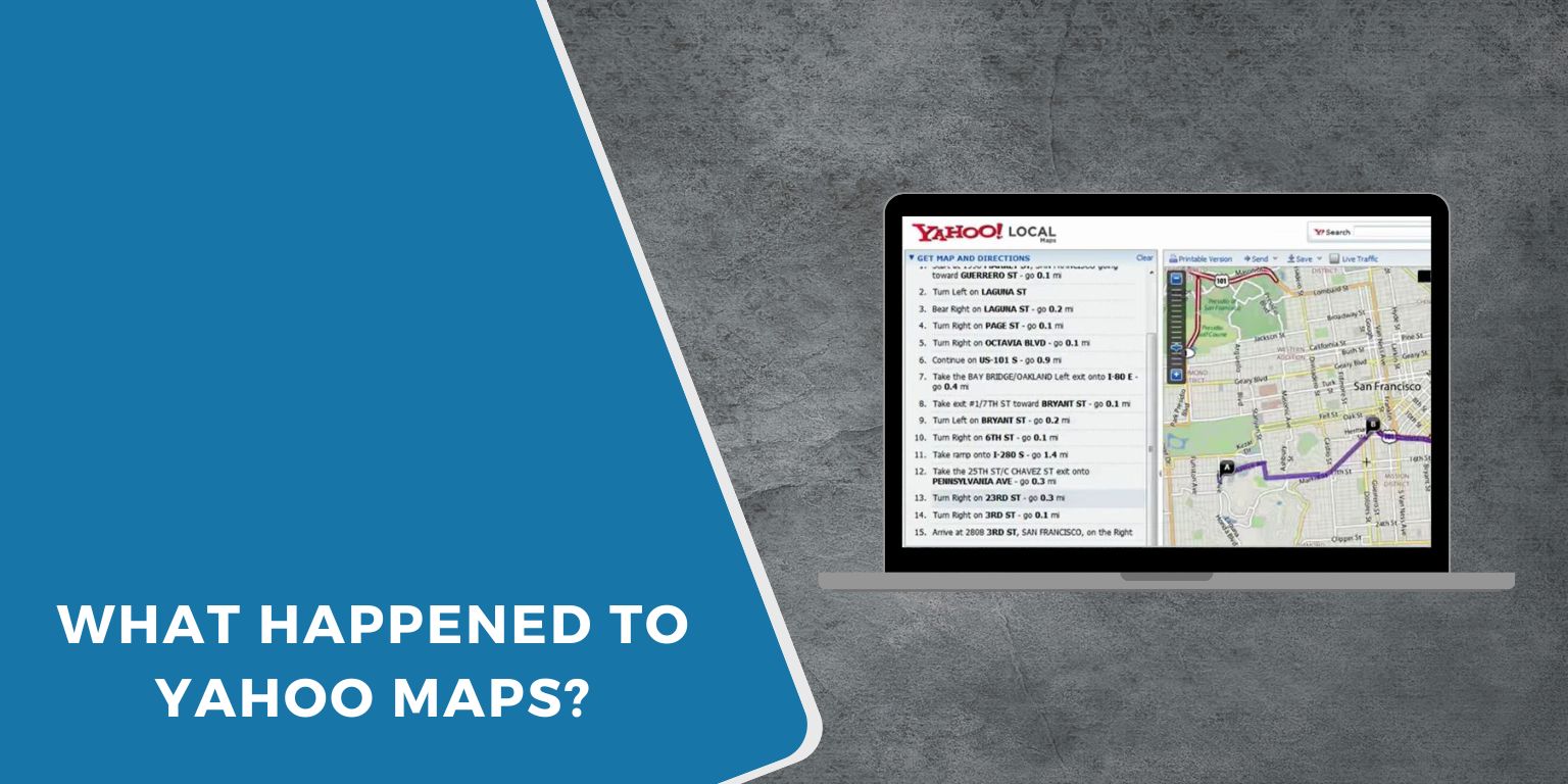
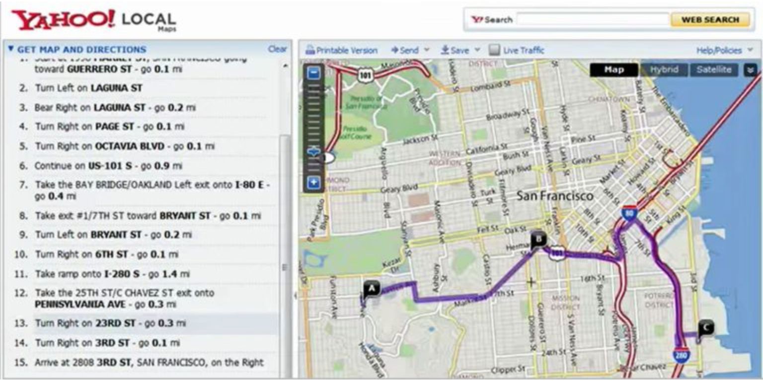 Yahoo Maps launched in 2002 as part of Yahoo’s Local Search platform. It provided users with access to street maps, directions, and business listings, a time when few competitors existed.
The service quickly gained attention for its clean layout and easy navigation. For many, it was the first web-based tool that made paper maps unnecessary.
Yahoo Maps allowed users to:
- Search for nearby businesses and addresses
- Get driving directions instantly
- View satellite and traffic maps
- Print or share routes online
It became a major part of Yahoo’s ecosystem alongside Yahoo Search, Yahoo Mail, and Yahoo Directory.
Yahoo Maps Features and Popularity
In the mid-2000s, Yahoo Maps was a leading name in online mapping. It competed with early MapQuest and the first versions of Google Maps.
The service focused on web users before smartphones took over. It integrated business listings, traffic data, and route planning directly into browsers.
For many, it was a daily tool for planning trips and finding stores or restaurants nearby.
Why Yahoo Maps Shut Down
By the early 2010s, Yahoo Maps started losing users as Google Maps became more advanced. Google’s mapping tools included satellite views, real-time navigation, and street-level imagery – things Yahoo didn’t develop as quickly.
In June 2015, Yahoo announced it would shut down Yahoo Maps to focus on stronger services like Yahoo Mail, Yahoo Search, and Tumblr.
The decision came after Verizon began restructuring Yahoo’s business to cut costs and improve performance.
Main reasons behind the shutdown included:
- Low traffic compared to Google and Apple Maps
- High maintenance costs for mapping licenses
- A shift toward content, news, and email products instead of web utilities
When Yahoo Officially Closed the Service
Yahoo Maps officially shut down in June 2015. After the closure, Yahoo redirected mapping features to other tools like Yahoo Weather and Yahoo Search. Users could still see maps inside those apps, but the standalone Yahoo Maps site was gone.
What Replaced Yahoo Maps
After closing its own mapping platform, Yahoo began using data from other providers. Its services now rely on Mapbox and OpenStreetMap for location visuals.
If you use Yahoo Weather or Yahoo Finance, the map displays come from these third-party partners.
Today, most users turn to these alternatives instead:
- Google Maps
- Bing Maps
- Apple Maps
- MapQuest
- OpenStreetMap
Each of these offers free online maps and navigation with modern features that Yahoo Maps once pioneered.
How Yahoo Uses Mapping Data Today
Even though Yahoo Maps no longer exists, Yahoo still uses mapping data behind the scenes. Yahoo Weather uses maps to show local forecasts, while Yahoo Search shows location-based results with pins and business names.
In Japan, Yahoo Japan still runs its own mapping and navigation services, completely separate from the U.S. version of Yahoo. Those maps are powered by Mapbox and OpenStreetMap technology.
The Legacy of Yahoo Maps
Yahoo Maps played a big part in shaping online navigation. It taught users how to find businesses, share routes, and print maps before GPS and smartphones were common.
Even though it’s gone, many of its early ideas – like directions, nearby listings, and real-time traffic – helped define what online maps look like today.
Yahoo Maps may have faded, but its influence is still visible in the mapping tools we use every day.
